


Wild Atlantic Way Pocket Map
The Perfect Way to Explore Ireland’s West Coast
Seiten
2019
Collins (Verlag)
978-0-00-832040-9 (ISBN)
Collins (Verlag)
978-0-00-832040-9 (ISBN)
- Titel ist leider vergriffen;
keine Neuauflage - Artikel merken
Zu diesem Artikel existiert eine Nachauflage
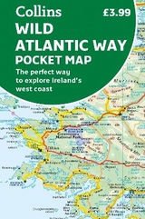
Explore new places with handy pocket maps from Collins.
Handy full colour map of Ireland’s Wild Atlantic Way with a high level of detail. Clear mapping of the full 2500 km (over 1500 miles), showing the road network and places of interest.
Ideal for tourists, locals, hikers and adventurers. Places of interest marked including famous film locations.
Excellent value and very detailed for its size.
Clear, detailed, full colour Collins road mapping is presented in a handy format ideal for the pocket or handbag. It is excellent value and covers the whole of the Wild Atlantic Way.
This map includes:
• Clear mapping at a scale of 8.7 miles to 1 inch
• National Tourist Routes showing best routes through the most scenic areas
• Places of interest include film locations such as Star Wars
• Tourist and signature locations clearly marked
• Suggested itineraries
• Detailed place names index
• Ideal companion to a sat-nav – it enables route planning and route sense-checking
Explore the world through accurate and up-to-date mapping.
| Erscheint lt. Verlag | 7.2.2019 |
|---|---|
| Zusatzinfo | Index |
| Verlagsort | London |
| Sprache | englisch |
| Maße | 90 x 140 mm |
| Gewicht | 40 g |
| Themenwelt | Reisen ► Karten / Stadtpläne / Atlanten ► Europa |
| ISBN-10 | 0-00-832040-3 / 0008320403 |
| ISBN-13 | 978-0-00-832040-9 / 9780008320409 |
| Zustand | Neuware |
| Haben Sie eine Frage zum Produkt? |
Mehr entdecken
aus dem Bereich
aus dem Bereich
Karte (gefalzt) (2023)
Freytag-Berndt und ARTARIA (Verlag)
12,90 €
Straßen- und Freizeitkarte 1:250.000
Karte (gefalzt) (2023)
Freytag-Berndt und ARTARIA (Verlag)
12,90 €
Narvik
Karte (gefalzt) (2023)
Freytag-Berndt und ARTARIA (Verlag)
12,90 €