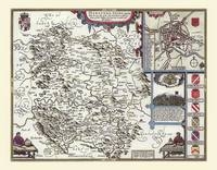
John Speed Map of Herefordshire 1611
20" x 16" Photographic Print of the County of Herefordshire - England
2010
Historical Images Ltd (Verlag)
978-1-84491-025-0 (ISBN)
Historical Images Ltd (Verlag)
978-1-84491-025-0 (ISBN)
Map of Herefordshire originally published in 1611 by John Speed, digitally re-mastered from an antique original and printed onto photographic quality media. Supplied flat in a polypropylene sleeve and back board, the 20" x 16" (approx. 508 mm x 406 mm) print can be removed from the protective sleeve for framing or retained in the sleeve.
A plan of Hereford is illustrated in the top right corner, together with a legend, showing the streets, churches and other important places in this old city.Beneath that is a beautiful drawing and history of a battle that took place on the borders of this shire in 1461. The detail gone into on this map is very interesting, with places like "The World's End" and "Marcley Hill, which was removed in Anno 1575" shown. The Malvern and "Hatterell" hills are also faithfully portrayed. The armorial devices of the Earls of Hereford are depicted along with two cartographers, and these just add the finishing touch to this fine piece of artwork.
A plan of Hereford is illustrated in the top right corner, together with a legend, showing the streets, churches and other important places in this old city.Beneath that is a beautiful drawing and history of a battle that took place on the borders of this shire in 1461. The detail gone into on this map is very interesting, with places like "The World's End" and "Marcley Hill, which was removed in Anno 1575" shown. The Malvern and "Hatterell" hills are also faithfully portrayed. The armorial devices of the Earls of Hereford are depicted along with two cartographers, and these just add the finishing touch to this fine piece of artwork.
| Erscheint lt. Verlag | 5.2.2010 |
|---|---|
| Verlagsort | Truro |
| Sprache | englisch |
| Maße | 508 x 406 mm |
| Themenwelt | Sachbuch/Ratgeber ► Geschichte / Politik ► Regional- / Landesgeschichte |
| Geisteswissenschaften ► Geschichte ► Hilfswissenschaften | |
| ISBN-10 | 1-84491-025-3 / 1844910253 |
| ISBN-13 | 978-1-84491-025-0 / 9781844910250 |
| Zustand | Neuware |
| Haben Sie eine Frage zum Produkt? |